Prior to any construction project, complete or partial surveying must be performed because it helps determine land boundaries. To successfully examine the area or construction site and construct a map, surveyors use various surveying accessories, tool and techniques such as computer-aided manual surveying, reflectorless tacheometry, laser-scanning, photogrammetry, surveying with DISTANZO and with DT-SMART.
Computer-Aided Manual Surveying Technique – This is a surveying technique that uses an electronic distancing meter and is very simple and inexpensive. The measurements are taken in direct contact with the building and generally, the dimensions are measured between the two surfaces against which the measuring device is held.
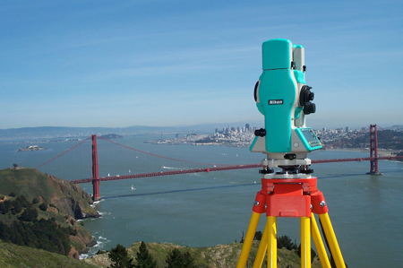
Reflectorless Tacheometry – The reflectorless tacheometry is a complex surveying method and has a few disadvantages comparing to the other techniques. There is no direct contact with the building, the point to-be-measured must be visible from the total station and the technique requires special skills.
Laser-Scanning – Laser-scanning, or a special form of reflectorless tacheometry, is a technique in which a building object is scanned in detail in order to produce a high-resolution set of points. Because of this the reflectorless tacheometry is not widely used, but is still common in limited areas of detailed measurement.
Photogrammetry – This is a non-relevant surveying technique for building, but a technique for irregularly structured building details. The photogrammetry requires special skills, including technical post-processing. The surveying accessories and tools for photogrammetry are developed in various different specialized fields.
Surveying With DISTANZO – One of the newest surveying methods is surveying with this digital device called DISTANZO. Once technical feasibility was established, detailed attention was paid to its design and ability to position and manage with one hand for use in typical building surveying applications. The device uses an integral tracking system to determine the position by pointing with a finger. DISTANZO can be connected to a laptop via second Systainer and create a CAD-model of collected data.
Surveying With DT-SMART – Another popular surveying innovation, DT-SMART, is a device that combines the most essential functions and relays other functions to remote equipment. It is based upon the current technological possibilities and combines the functions of a distance-meter and a simple building tacheometer. It transmits data via Bluetooth directly to a laptop or a tablet with created database and it does not requires any complex display and button panel. Instead, it has a simple display to show the resulting measurements and a few needed buttons to initiate measurements.